
The Rivers State government is not taking chances with the recent warning as the state’s Commissioner for Environment, Professor Roseline Konya, told residents to stop blocking waterways with buildings and other projects, warning that government agencies were set to demolish any property found to be obstructing water flow.
The National Emergency Management Agency (NEMA) and Nigeria Hydrological Service Agency (NIHSA) recently warned of heavy floods in some states along the banks of Rivers Niger and Benue. Residents of communities in the likely states-Kebbi, Niger, Kwara, Edo, Kogi, Anambra, Rivers, Bayelsa and Delta from the River Niger axis and Taraba, Benue and Adamawa from the River Benue axis have been asked to prepare for a similarity of the 2012 flood, as all its indices have manifested. How are the states preparing, and how are the people living in affected communities responding?
The Rivers State government is not taking chances with the recent warning as the state’s Commissioner for Environment, Professor Roseline Konya, told residents to stop blocking waterways with buildings and other projects, warning that government agencies were set to demolish any property found to be obstructing water flow.
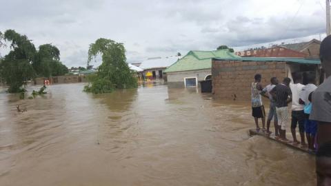
Residents of Port Harcourt and some communities in the state are however lamenting over the rampaging flood which has displaced thousands and destroyed property worth millions of naira. Residents of Port Harcourt City, Obio Akpor, Oyigbo and old Ahoada were recently stunned by heavy floods which displaced hundreds. In March this year, residents of Nkpolu-Rumuigbo community, Obiwali road and Rumuekini all in Obio Akpor Local Government Area and those of Diobu, parts of D Line, Rumukalagbo, old GRA, especially Odi Street and Delta Hotel of Forces Avenue as well as Bank Road in Port Harcourt City Local Government Area cried to the state government over the flooding. Of a very pathetic story was the flooding of Eneka community in Obio Akpor Local Government Area. Rivers State Deputy Governor, Dr. Ipalibo Harry during an assessment of the affected areas promised that the government would do everything within its powers to address the immediate and remote causes of the flooding. But she accused residents of building houses in water channels, and the residents called for quick and sustainable measures to tackle the problem.
In 2012, communities and major streets of Port Harcourt, Obio Akpor, Oyigbo, Eleme, Egbema , Omoku, Ahoada and other rural communities were submerged by flood while hundreds of residents were displaced.
2012 a bitter reminder in Bayelsa
The heavy floods that swept parts of Bayelsa in 2012 might have been a surprise to many residents of the coastal state, but the people and government of the state are working very carefully against a re-occurrence. Before the recent flood warning, the people had already started preparing for the rainy season and possible rise in water level. Between April and May this year, wooden bridges popularly called “Monkey bridges” made by the locals had sprung up in most towns in the state, including Yenagoa, the capital. Findings by Daily Trust revealed that after the 2012 floods, people began constructing the wooden bridges around their households and streets whenever the rains approach, and in the case of a rise in water level, they resort to it as alternative walkways. But did that prevent disaster? In 2012, virtually all the communities along the river bank such as Sagbama, Adagbabiri, Peretorugbene, Agbere, Ofoni, Ayamasa, Sabagriea, Igbedi, Famgbe, Yenaka, Ogu, Fortorugbene, Agbura, Aguadama-Epetiama, Oporoma, Ndoro, Tombia, Peremabiri, Elemebiri, Asamabiri, Angalabiri, Opokuma, Odi, Kaiama, Biseni, Gbarantoru, Tombia Amassoma and Ekeremor among others were submerged. In some communities, residential and public buildings including schools, banks, churches and town halls were overtaken by floods, leaving thousands of families homeless with their means of livelihood destroyed.
The state government, therefore, began regular clearance of drainages, gutters and water ways to prevent a re-occurrence. The government banned waste disposal in gutters and introduced central disposal centres in virtually all the streets in the state capital, with the officials of the Environmental Sanitation Agency evacuating them daily. The introduction of a monthly sanitation exercise has also contributed not only to the cleanliness but to ease the gutters and canals from waste.
Soon after the recent flood alert, the government set up a desk in the Ministry of Environment with some dedicated numbers for citizens and residents to report any rise in water level for prompt intervention.
Kogi
Parts of Ajaokuta-Lokoja highway on the brink
Kogi was among states worst hit by the devastating flood in 2012 which led to the displacement of over 600,000 people, loss of lives, destruction of infrastructure, crops and farmlands. There are nine flood-prone local government areas in the state-Lokoja, Kogi/Kotonkarfe, Ibaji, Bassa, Igalamela, Omala, Ajaokuta, Ofu, Idah and Igalamela/Odolu.
Residents of these areas have begun relocating in large numbers to designated temporary camps opened by the state government just as others are putting up with their loved ones who reside upland. This is even as parts of the ever-busy Lokoja-Ajaokuta highway which is a major link between the North and East of the country is being threatened by flood.
Already, many communities on the flood plains in Kogi/Kotonkarfe, Ibaji, Lokoja, Ajaokuta and Bassa among others have been submerged by flood in the past few days.
In Kogi/Kotonkarfe alone, over 64 communities were said to have been submerged.
At Ganaja Village axis in Lokoja, the state capital, our correspondent observed that the River Niger has overflowed its banks, submerging several houses and now advancing towards portions of the Ajaokuta-Lokoja highway.
Over 50,000 people have already been displaced, according to the state emergency management agency.
The Executive Secretary of the agency, Alhassan Ayegba, said more people had continued to relocate to camps while others decided to put up with relatives.
This is just as the level of water at the River Niger has continued to rise daily. Abdullahi Bello who lives at Adankolo in Lokoja close to the bank of the River Niger, told Daily Trust that many of his neighbors had relocated.
Edo
Riverine residents flee
Riverine communities around the banks of the River Niger in Edo State have started feeling as many houses have been submerged in seven communities.
The communities are Udaba, Ofukpo, Agbaburu, Osomegbe, Ukpeko, Ugochi and Anegbette. Farmlands with crops such as cassava, yams, rice, maize, groundnuts and others were also submerged.
It was gathered that farmers in the affected communities have embarked on premature harvest of their crops in order to avoid total loss.
It was gathered that no serious arrangement has been put in place by either the local or state government in preparation for the flood. For example, no emergency camp has been erected while the federal government camp in the area is yet to be prepared for victims even as flood has started ravaging communities.
It was gathered that after the flood the local government began cleaning and fumigating the federal government camp.
Taraba urges mass relocation
Hundreds of farmlands were submerged by flood in four local government areas of Taraba State where crops estimated at several millions of Naira were destroyed after several days of heavy down pour and release of water from the Lagddo Dam in Cameroon.
The local government areas affected include Gassol, Ibbi, Lau and Karim Lamido.
Though no life was lost, resident of villages along the bank of the River Benue are apprehensive of a repeat of the 2012 flood which claimed several lives and destroyed hundreds of houses and crops.
In Gassol, the chairman, Alhaji Yahuza Ya’u, told Daily Trust that several farmlands were destroyed in Namnai and Shagarda areas.
He said two bridges were damaged, adding that his council had set up a desk to compile the list of affected villages and the value of crops destroyed.
The chairman said residents of villages along the River Benue had been advised to relocate.
“We advised our people to stay clear of areas close to the River Benue because of the volume of water,” he said.
In Ibbi LGA, a farmer, Mallam Zulkifilu Musa, said the volume of water had increased within the past two days and farms along the bank of the river were submerged.
The National Emergency Management Agency organised a one-day stakeholders disaster management forum in Jalingo on Wednesday. The Head of Operations of the Yola office of the agency, Mallam Abbani Imam Garki, said the forum aimed at brain storming on issues related to disaster management, especially on the looming flood.
Benue
Residents resort to self help
Residents of flood prone areas in Benue State are currently making communal efforts on the impending flood. Residents of parts of Idye, Wadata, Achusa, Zone 4 High level, Kyado villa, opposite Judges’ Quarters and Wurukum areas of Makurdi, Guma, Otukpo and Logo Local Government Areas which experienced heavy flooding last year are however yet to witness same this year.
The state government earlier dug drainages in Makurdi metropolis and constructed several canals in areas where flooding was heavy last year. The Executive Secretary of the Benue State Emergency Management Agency (SEMA), Emmanuel Shior, said a lot of measures had been put in place including the opening up of major water channels to control any likely flood.
Shior told our correspondent that among other measures, the state government constructed water channels in places such as Idye to Achussa while the governor had directed the agency, water ministry, urban development board and other relevant agencies to sensitise the public.
He also said residents of Makurdi and its environs had opened up their gutters while his agency continued to advise those whose houses are on water plains to relocate.
He added that the agency had prepared the Makurdi International Market for those that might be displaced by the flood, stressing however that some people in places likely to be affected usually ignored the warnings and advice to move upland.
Shior noted that the governor had approved money to fumigate the market environment while mattresses and other essential items had been bought in preparedness.
“Once the water is ready to be release, they (federal agencies) would alert us. The flood presently devastating some states is the one from tributaries of Gongola and Adamawa. What we (Benue) have now is rainfall, we haven’t experience flood yet,” Shior added.
Our correspondent who went around some flood prone areas in Makurdi observed that some neighbourhoods had made efforts to evacuate blocked drainages.
Kebbi
19 LGAs battle flood
Nineteen local government areas in Kebbi State were badly affected by flood following heavy rainfall and water from the River Niger which stretches across more than 14 of its local government areas. Because of this, local government areas such as Bagudo, Shanga, Yauri, Ngaski, Lolo and Dandi suffered more havoc in the flood incidents in which 19 people were said to have lost their lives.
Many communities in Kebbi State are prone to flood. In 2016 and 2017 many farmlands and communities in the state were submerged by flood. In 2012 more than 250 settlements particularly those around the river banks were swept away while over 2,500 farmlands and livestock were lost to the flood. The State Emergency Management Agency (SEMA) Acting Executive Director, Alhaji Abbas Kamba while speaking to our correspondent in Birnin Kebbi said the local government areas badly affected are; Dandi, Argungu,Bagudo,Jega, Suru, Koko/Besse, Kalgo, Bunza, Shanga, Danko-Wasagu, Aliero, Maiyama and Birnin Kebbi. In Shanga alone, more than 30 communities and farmlands were completely submerged in the flood.
Given the level of damage the flood has caused in many areas of the state, the Presidency directed the National Emergency Management Agency (NEMA) to summit its report on the flood incident in the state within 72 hours. The Deputy Director of Research and Rescue Department of NEMA, Dr Onimode Bandele during an emergency meeting with officials of Kebbi State Emergency Agency (KSEMA) in Birnin Kebbi said the agency would hold emergency meetings with stakeholders in the state to ascertain the number of farmlands, houses and death caused by the flood. He said they would also gather data on those affected by the flood.
To prevent further loss of lives and property SEMA said it had officially written to NEMA and other emergency management groups and organizations to come to its aid. Speaking to our correspondent, the acting executive director of SEMA, Alhaji Kamba, said many other relevant agencies in the state had been put on alert for flood incident in any part of the state.
Niger
Situation beyond our capacity-Gov
A motley crowd of villagers waited anxiously by the bank of the Bouna River at a point in Soho Shatta community in Pyata ward, Bosso LGA of Niger State.
Across the tiny river which serves as border between Bosso and Shiroro LGA, another crowd of sympathizers also waited in anticipation at a point in Sabo Shatta.
The Director General of the Niger State Emergency Management Agency (NSEMA) confirmed at the forum that about 40 lives had been lost already to flood this year with property valued at millions of naira including farmlands already destroyed. A day to the meeting, six communities were submerged in Shiroro LGA of the state. The affected communities include Gungu, Ungawar-Bagudu-Alhaji Umoru, Rafin Gora, Sani-Farin Mutum, Mashigi-Gungu, Ungwar Aboki. The communities were already due for relocation because of the ongoing works on the Zungeru dam. The incident threw up an immense humanitarian crisis with over 2,000 persons displaced. They are all temporarily sheltered at the Zungeru Primary School. Governor Abubakar Sani undertook an aerial tour of flood ravaged areas in Lapai LGA.
Delta
Thousands of residents displaced
Thousands of residents of Abuta, Otuogu, Akwuebunu and other riverside suburbs of Asaba, the Delta State capital, have fled for safety as floods submerged homes and clusters of coastal neighbourhoods along the banks of the Niger River. Thursday’s downpour which started at about 6.30am flooded major roads, streets, schools, residences and offices in Asaba, the state capital and its environs gushing out from drains and gutters as it swept through into the River Niger.
Although no life was reported lost in the flood, our correspondent observed that most of the submerged houses were already deserted by the occupants who reportedly deployed wooden boats and tricycles to evacuate their valuables.
Though the state government had issued statements on flood alert, no practical arrangements were on ground.
The state government had a fortnight ago urged residents in coastal areas to move to safer grounds following the flood alert.
Besides, the government apparently has no contingency measures to cope with the looming disaster, except that the Commissioner for Special Duties, Ernest Ogwezzy, said recently at a media parley that plans were underway to establish emergency camps in Asaba, Kwale, Ughelli, Sapele and Warri.
Ogwezzy also told officials of the National Emergency Management Agency (NEMA), who visited the state that government had identified possible safe grounds that could be used to set up Internally Displaced Persons (IDPs) camps, disclosing a memo was before the governor requesting to stock its warehouse with relief items for the prospective victims.